Understanding your designated zone in advance is crucial for swift evacuation in an emergency. Identify your zone, then note it down, take a screenshot, or memorize it to ensure you can reference it quickly when necessary.
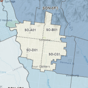
The City of Sonoma is divided into four quadrants or zones:
- Zone SO-A01, which includes all areas in Sonoma city limits that are west of First Street West and north of West Napa Street (View/Download Map).
- Zone SO-B01, which includes all areas in Sonoma city limits that are east of First S Street West and north of East Napa Street (View/Download Map)
- Zone SO-C01, which includes all areas in Sonoma city limits that are east of Broadway and south of East Napa Street (View/Download Map)
- Zone SO-D01, which includes all areas in Sonoma city limits that are west of Broadway and south of West Napa Street (View/Download Map)
- If you live outside of the City of Sonoma, find your evacuation zone HERE

Evacuation Checklist
If you are asked to evacuate due to danger, you may have little time to grab your Go Bag and get safe. Sometimes you do have a bit more time. Here is a list to help you get started planning what you may want to take if you have an hour or more before you need to go.
This checklist should be customized to your family – be sure to have a family discussion about what would be your first priorities, if you had some extra time. Visit the Sonoma County Emergency Website for more checklists and information in English and Spanish.
Important Note: These are the City’s current best-laid plans for an efficient evacuation of our community during a large-scale emergency. However, it is important to understand, that depending on conditions and varying hazards, modifications to designated zones could become necessary during an emergency. If changes to the boundaries of a zone were needed during an emergency, rather than issuing an evacuation order for a designated zone, the evacuation order may instead refer to geographic boundaries, streets, or landmarks.
Help first responders evacuate neighborhoods quickly during a disaster – register your gate code and get your free evacuation tag!
The Sheriff’s Office is giving away evacuation tags to residents living in unincorporated Sonoma County and the City of Sonoma. Evacuation tags are a new tool to help quickly ensure that neighborhoods are evacuated during a disaster. Residents tie the tag in a location that is highly visible when they evacuate. This saves time because first responders don’t have to tie their own ribbon on the property and they can immediately check the next home. We’ve learned that seconds can count during evacuations and we are excited to bring this new time-saving tool to our residents. Tags are available at the Sonoma Police Department (175 First Street West, Sonoma) during business hours.
Learn more about evacuation tags, how and when to use them, and where you pick up a tag on the Sonoma Sheriff’s website.
Gate Code Registration
Use the form on the Sonoma Sheriff’s website to register or update your gate code if you live in the City of Sonoma or unincorporated Sonoma County. When you register your gate code, a dispatcher will enter it into our secure system. During an emergency, such as an evacuation or response to a 911 call, a dispatcher will relay your code to the responding deputy. This allows the deputy to quickly enter your property and reach your home. Learn more at the Sonoma Sheriff’s website.
Prepare today for an emergency by reviewing the Emergency Preparedness page, signing up for emergency alerts, and packing your “Go Bag.”


If you are one of the 25,000 or so lower valley people who don’t live in Sonoma, look on this map to find your evac zone https://sonomacounty.maps.arcgis.com/apps/instant/lookup/index.html?appid=58500b81c61148279263bed52403c81a