Rogers Creek Fault is Waiting
By David Bolling
With the nation’s focus on the catastrophic wildfires in Los Angeles, the last thing anyone wants to read about, think about or prepare for is another big California earthquake.
But the harsh reality is that California is on the edge – on the edge of the continent, and on the edge of a seismic sandwich, one tectonic plate racing north to Alaska at the breathtaking rate of about two inches a year, the other plate almost anchored in place, moving slowly to the southwest, while its weathered, western face is steadily ground down, chiseled away, leaving geologic rubble in its path.
According to the United States Geological Survey (USGS), at some point in time, Los Angeles, which is riding the Pacific Plate north, may become a close neighbor of San Francisco, which is sitting uncertainly on the edge of the North American Plate. Perhaps someday LA will end up out near the Farallon Islands, finally safe from wildfires.
That tension, and the seismic stress it reflects, has become the focus of a multi-agency initiative called the Working Group on California Earthquake Probabilities, which releases periodic reports providing comprehensive models of earthquake probability all over the state. Those reports, called Uniform California Earthquake Rupture Forecasts (UCERF), were most recently updated in 2017 WITH UCERF3. What UCERF3 tells us is that the Sonoma Valley is privileged (fated?) to be the site of the second-most likely major earthquake, between now and 2038, in all of California.
That’s because, in its inexorable northward migration, as the Pacific Plate is steadily grinding against the North American Plate, it is constantly building up tension that has to find relief, and our neighborhood fault is favored for that role.
Look at a USGS seismic map of the Bay Area and you’ll see what looks like a series of parallel railroad tracks that are, in fact, identified earthquake faults. And in that grid you will easily notice an orange stripe running up along the East Bay, across the Carquinez Straits and up past Sonoma Valley on its way through Santa Rosa to points north.
The result of all this tectonic tension?
The consensus of earth scientists agrees there is a 99 percent probability of a 6.7 or greater magnitude earthquake occurring somewhere in California in a 30 year window that runs forward from about 2007. And of all the fault systems in the state on which that quake could occur, scientists are equally certain the second most likely candidate, at present, is the Hayward-Rogers Creek Fault system, that runs along the western flank of Sonoma Mountain, just a ridge away from Temelec, Sonoma, the Springs, Glen Ellen, Kenwood, Oakmont, into and through Santa Rosa and all the way up to Healdsburg.
But that’s only part of the out-of-sight seismic picture. According to research by the U.S. Geological Survey and its companion state and federal agencies, there is virtual certainty that the Rogers Creek Fault is connected to the south with the Hayward Fault, which runs for 75 miles from San Jose, along the base of the East Bay hills, through Hayward, Oakland, Berkeley, Richmond and under the Carquinez Straits. Along the way it runs directly under Cal Stadium, numerous BART lines, Lake Temescal, Contra Costa College, various freeways and the Hetch Hetchy aqueduct which supplies the East Bay and San Francisco with most of their drinking water.
Earthquake magnitudes are equated to fault length. The longer the fault, the larger the potential temblor. So, when you add the 75 miles of the Hayward fault to the Rogers Creek Fault, you get a pretty big crack in the Earth.
How big an earthquake could that system generate? The California Geologic Survey calculated that question in 2008 and created a planning scenario based on a 7.5 magnitude quake on the Hayward Fault. Subsequent estimates for a maximum event on the Rogers Creek Fault go up to at least 7.4 if the two ends of the system ruptured together.
The biggest earthquake on the Hayward fault in recorded history, with an estimated magnitude of 7.0, occurred in 1868, producing a maximum horizontal displacement of about six feet. Given that the geologic record indicates big events on the Hayward Fault have occurred roughly every 140 years (the so-called “occurrence rate”), looking forward from 1868, the Hayward Fault may now be overdue.
And that helps explain the USGS calculation that there is a 30 percent or greater likelihood of a 6.7 percent or larger event on the Rogers Creek fault in the 30-year window between 2008 and 2038.

According to a 2005 bulletin from the Seismological Society of America, the last major event on Rogers Creek occurred sometime before 1776, with an occurrence rate of something on the order of 220 years. Add those numbers together and you get 1996 as the year to start packing your emergency go-bag. All of which makes 2038 seem uncomfortably close.
Let’s stop right there for a major caveat. Earthquake probability is an evolving science, and probability is not inevitability. The only thing inevitable about earthquakes in California is that they are going to keep happening. But how often, and how big? Only estimates are available. And earthquake damage depends not only on magnitude, but on duration, surrounding ground composition, and numerous other variables.
So, if there really is a 6.7 magnitude earthquake on the Rogers Creek Fault system sometime by or before 2038, how bad would that event be?

If we’re talking about the Hayward Fault, the 2008 planning scenario for a 7.5 event, calculated $165 billion in financial damage to infrastructure (not including post-quake fire losses) and between 1,500 and 4,500 deaths, with 100,000 people homeless. More than 1,000 roads (including trans-bay bridges) could be closed for significant periods of time, and liquefaction of the landfill the area’s major airports are built on could render them inoperable.
In Sonoma Valley, the damage question is addressed in the Sonoma County Hazard Mitigation Plan, which relies on intricate computer modeling to produce estimated damage and casualty figures. The plan was adopted by the Board of Supervisors in 2016, updated in 2021 and is due for another reset. Damage figures are estimated by a computer model developed by FEMA called HAZUS-MH, and it basically compiles loss estimates.
According to that model, the Rogers Creek earthquake scenario would result in strong, damaging ground shaking in areas near the fault, including Santa Rosa, Petaluma and Sonoma. The shaking will cause any variety of liquefaction, slumping, landslides, lateral spreads and surface rupture. Water, gas and sewer lines could be disrupted. The HAZUS-MH model predicts 11,427 multi-residential units, 3,615 commercial units, and 1,229 industrial units would be moderately to completely damaged.
Water, power, and phone service would likely be unavailable immediately after the event. An estimated 19,372 households would be without water, and about 50,000 households would be without electricity. Cell and landline phone service would be affected but would likely be restored within days.
Key roads would be impacted, including Highways 101, 12, 116 and 121. Total income losses would exceed $565 million, and capital losses would approach $3 billion.
If the earthquake occurred in the middle of a work day, 42 fatalities would occur and 972 people would be injured badly enough to require medical care or hospitalization.
These are, again, estimates and many variables would be in play, including time of day, season, weather and soil saturation. Earthquakes commonly cause fires, but the model does not estimate the subsequent impact of a quake-caused wildfire.
Taking earthquakes seriously means being prepared. In the next part of this series we will explore how to minimize earthquake damage; we will examine the earthquake risk to Sonoma Valley Schools, notably including Altimira Middle School; and we will conclude with a review of the seismic impacts of other North Bay quakes in recent history.
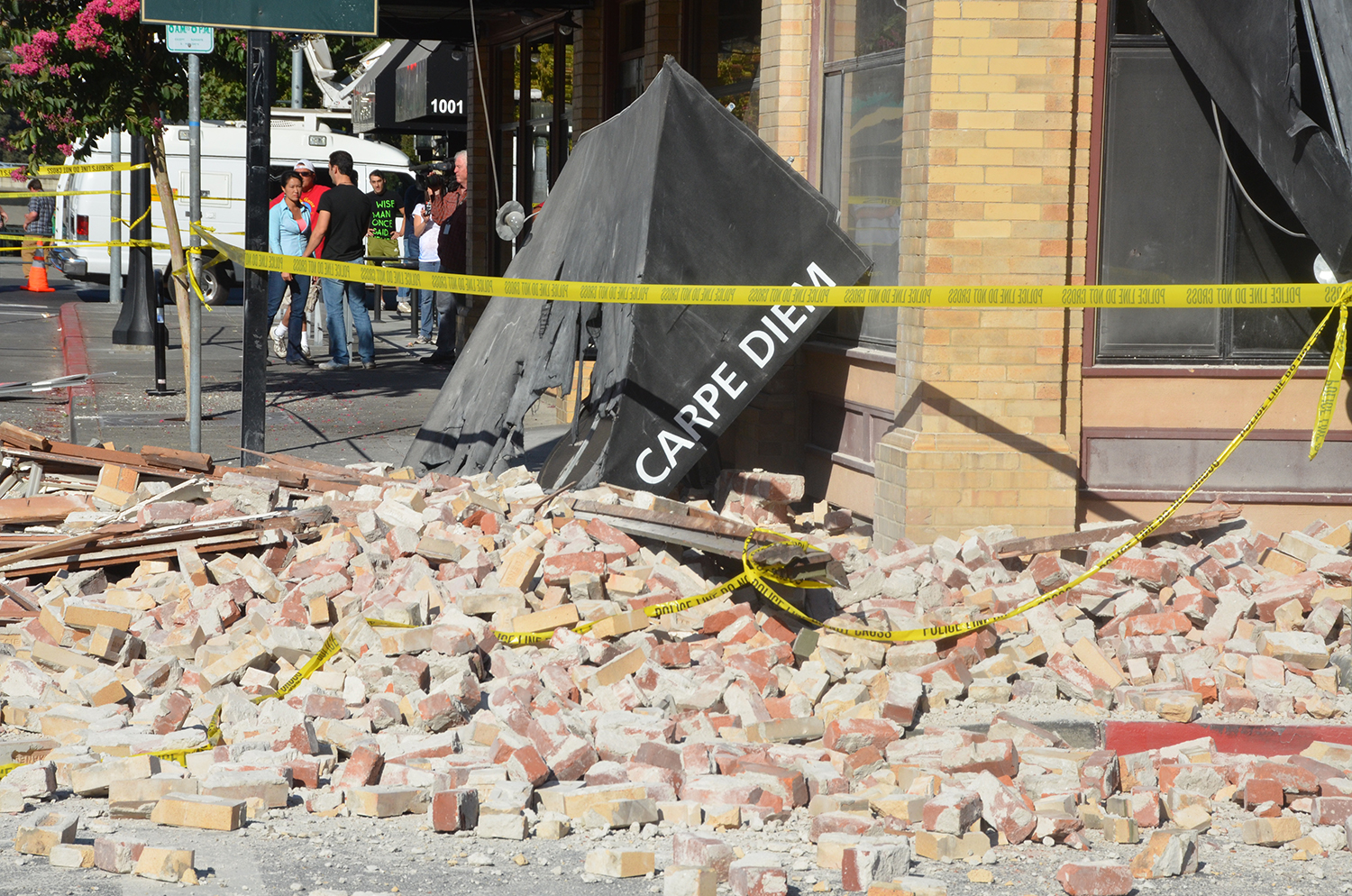
2014 Napa earthquake photos by David Bolling


Thanks for the clear information
The Hayward earthquake cluster is very unusual and could presage a much larger event. As the faults grind away and pressure builds prior to a quake, there is a distinct change in the localized magnetic fields. The intensity and duration of this magnetic anomoly can give ample warning of an impending event. This was the case with the Napa quake. At this moment, the perturberance of the fields is manifest and strong. The longer it persists, the greater the chance of a significant quake. Get Ready!