
A community information meeting to discuss the SAFE Report will be held February 24, at 6:30 p.m. at Altimira Middle School, 17805 Arnold Drive, Sonoma.
The following questions and answers about the SAFE report and its conclusions have been provided by VOTMA:
Q: What are some key findings of the SAFE report?
- The available roadway supply is “NOT SUFFICIENT” to service the present evacuation
- Evacuation traffic quickly causes gridlock on north valley roads, reducing speeds to 0-3 MPH for three hours or more.
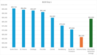
- Individual valley residents can face evacuation times of 3 or more hours. (see Fig C-3) And it can take 4 to 8 hours to evacuate 90% of Sonoma Valley.
- If SDC and Hanna are built out, evacuation times along Arnold Drive and Highway 12 south would increase significantly. (see Fig C-3 and C-4)
Q: What is the area of Sonoma Valley being studied? Why was this area chosen?
The area of KLD’s study was bounded on the north by Oakmont, on the south by Petaluma Avenue in Sonoma, and bounded by the mountain ridgelines to the east and west. Given the limited time and resources available, the focus was on Sonoma Valley, exclusive of the City of Sonoma and points south.
Q: What are Evacuation Regions and how are they used in the study?
A: Evacuation Regions are the key units of study and are critical to understanding the KLD study results. Typically, a Region will be a set of Sonoma County Evacuation Zones (SCEZ) that will evacuate at the same time. And a Staged Region will be a set of Sonoma county evacuation zones that will be evacuated in a sequential manner, not all at once. Regions R04 through R13 represent combinations of SECZ likely to be evacuated concurrently. Region R14 represents the simultaneous evacuation of all SCEZ within Sonoma Valley. Regions R01-R03 represent staged evacuation scenarios. See table D-1 for detailed definitions of each region.
Q: What does it mean to evacuate a region?
A: Evacuation times for a Region represent the time to evacuate from any of the Sonoma county evacuation zones (SCEZ) in that Region to any adjacent evacuation zone not in that Region. It is not the time it will take to get out of Sonoma Valley and not necessarily the time it will take to get to safety. So the time to evacuate outside of Sonoma Valley may be much longer
Q: What is a Shadow Region and how do they impact evacuations?
A: A Shadow Region is an area outside of but adjacent to the Sonoma Valley study area. The southern Shadow Region consists of the City of Sonoma and all the land south to route 121. The northern Shadow Region consists of the parts of Santa Rosa around Annadel State Park including the Skyhawk Community and parts of Rincon Valley. The road conditions and population of Shadow Regions can severely impact traffic from the Valley as it evacuates to or through the Shadow Region. KLD studies the roads and traffic load of Shadow Regions but does not study the actual evacuation of a Shadow Region.
Q: Some people will evacuate before required. How is that modeled?
A: Demographic surveys found that about 32% of the population of an evacuation zone as well as about 32% of an adjacent Shadow Region will voluntarily evacuate on their own when adjacent zones are required to evacuate. This is taken into account when modeling each evacuation scenario.
Q: Does the SAFE study evaluate different fire locations and/or if roads are blocked?
A: When evacuating a region, the study measures three scenarios: (1) people can evacuate in all directions, (2) people can evacuate only to the north, (3) people can evacuate only to the south. KLD’s tools can model any other scenarios but we have done only these three so far. It’s important to note that almost all the roads in Sonoma Valley are two-lane roads, with little or no shoulders so any road obstruction such as a fallen tree, accident, or stalled car can have devastating consequences. The SAFE study does not model or predict such occurrences.
Q: Does the SAFE study include evacuation plans for Sonoma Valley?
A: No. That would not be appropriate. Wildfire evacuation planning, public education, and information are handled by Sonoma County government agencies. Evacuation plans are carried out by local fire and police departments. In general, Fire officials issue and direct the evacuation and the Police carry it out. The SAFE study is not an evacuation plan, it is an evacuation time estimate analysis that can be used by Sonoma County agencies.
Q: Who is KLD? Are they qualified to do this kind of study?
KLD Associates, headquartered in San Antonio TX, has conducted evacuation studies and planning for every nuclear power plant in the US and Canada, terrorist attack planning for Washington DC, hurricane evacuation planning for Florida, and wildfire evacuation studies and planning for a dozen cities in the western US. KLD’s methodology has been evaluated and vetted by federal agencies and selected by numerous federal, state, and local agencies to do critical life-saving analysis and planning. Go to KLDassociates.com for more information.
How the study impacts Sonoma Valley
Q: Didn’t the county already do an evacuation study of Sonoma Valley?
A: In 2022 Permit Sonoma commissioned an evacuation study as part of the Environmental Impact Report (EIR) for the site specific plan for the Sonoma Developmental Center (SDC). That study looked at roughly tripling the population of Glen Ellen but claimed that that huge increase in traffic would increase the evacuation time in the SDC area by at most 90 seconds and would actually decrease evacuation time for the SDC campus area. Also, the consultants supplied no data, no modeling information, nor methodology to explain how these conclusions were reached. The community strongly rejected this study and they asked for a more open, scientific, and data driven study.
Q: Why did VOTMA commission this study?
A: Many citizens and community groups recognized the need for a comprehensive, data- driven, scientific study of wildfire evacuation issues in Sonoma Valley in order to (1) understand the evacuation issues and safety risks today and (2) be able to evaluate the impact of new development and new road changes in the future. VOTMA agreed to be the umbrella organization to accomplish this study.
Q: Who is VOTMA?
A: The Valley of the Moon Alliance (VOTMA) is a California 501(c)(3) Non-Profit Corporation. Its organizational purpose includes supporting balanced development, especially affordable housing, preservation of Sonoma Valley rural history, conservation of the natural resources of Sonoma, and thorough analysis of public and private initiatives that could result in compromising public safety and misuse of and disregard for those resources and principles. Go to VOTMA.org for more info.
Q: What organizations contributed to this study?
A: Dozens of individual contributors, as well as the following community organizations: The Glen Ellen Forum, the Glen Ellen Historical Society, Grow Smart Sonoma, Eldridge For All, the Sonoma Mountain Conservancy, Friends of North Sonoma Valley, Sonoma Valley Next 100, and many other civic groups.
Q: What is the objective of this study?
A: The analysis was commissioned to provide public agencies, governmental officials, and the public itself with reliable, state of the art, evidence-based analyses of evacuation times for Sonoma Valley in the event of a catastrophic wildfire. In short, this document is about promoting public safety. We hope the Board of Supervisors and other Sonoma County officials will use this study in making decisions on roadways, traffic control, emergency procedures, and evaluating large impactful development projects.
Q: Why do this study now?
A: The County is engaged in reviewing various development projects in the Sonoma Valley that will challenge the limits of evacuation capabilities, including the development project at SDC, Hanna development project, and the Springs Specific Plan. In addition, the County is starting its General Plan update planning process. We felt it would be productive to set the standard for the level of analysis required to responsibly evaluate the many challenges Sonoma will face in the future decade.
Q: What do you hope the Sonoma County Board of Supervisors will do with this study?
A: We ask that the Board of Supervisors and its responsible County offices do the following:
- Implement evacuation planning now with the reality-based evidence from the
- Incorporate the evidence from the study into the evacuation assessment of all pending and new land use applications and specific plans involving Sonoma Valley.
- Incorporate the data and results of the study into the proceedings for the upcoming General Plan Housing and Safety elements.
A complete list of files relating to the SAFE report can be found here: https://votma.org/files
Photo By David Bolling


Be First to Comment