Priority Conservation Areas (PCAs) are regionally significant areas to be protected and improved. PCAs include natural habitats, farms and ranchlands, recreation areas, urban green spaces and locations that can help fight the effects of climate change.
PCAs are nominated by local jurisdictions with land use authority (such as open space districts, city and county parks and recreation departments, and other local entities) and adopted by the Association of Bay Area Governments (ABAG). More than 180 existing PCAs have been adopted by ABAG.
As explained in the staff report prepared for the City Council meeting of June 4, 2025 at 6 p.m., PCA’s are designated geographic areas identified to support the Bay Area’s regional conservation, resilience, and sustainability objectives. First introduced in 2007, the PCA program was updated in 2024 to ensure improved alignment with regional planning and funding opportunities. PCA’s are characterized as one or more types.
- Natural Lands
- Agricultural & Working Lands
- Urban Greening
- Recreation
- Climate Adaptation (must overlap with one other PCA type)
The PCA designation encourages the preservation or enhancement of areas with high conservation values or needs. The PCA nomination process is locally driven, while designating PCA’s depends on predefined priority areas determined by the Association of Bay Area Governments (ABAG) and the Metropolitan Transportation Commission (MTC) as seen in Attachment C. PCAs are voluntary designations, and do not take precedence over local control. Under Government Code section 65080, subdivision (b)(2)(K), a sustainable communities’ strategy (Plan Bay Area) does not supersede a city’s land use authority.
Staff reviewed the mapped eligibility areas and used these predefined priority areas to identify and propose Priority Conservation Areas based on local priorities and comments received through the general plan update process to date. Meetings were held with ABAG/MTC to determine qualifying PCAs under Attachment D and staff is confident that the proposed PCAs will serve the needs of the community and meet the objectives of the City of Sonoma General Plan. If the City Council nominates the proposed PCAs, staff will submit to ABAG/MTC for designation allowing the City to be eligible for the PCA Grant Program, which provides funding for acquisition, restoration, and public access improvements.
Analysis of Proposed New PCA’s
Proposed PCA Name: Sonoma Creek PCA
Location: From Ramon Street to Smith Street
Type(s): Urban Greening, Recreation, and Climate Adaptation
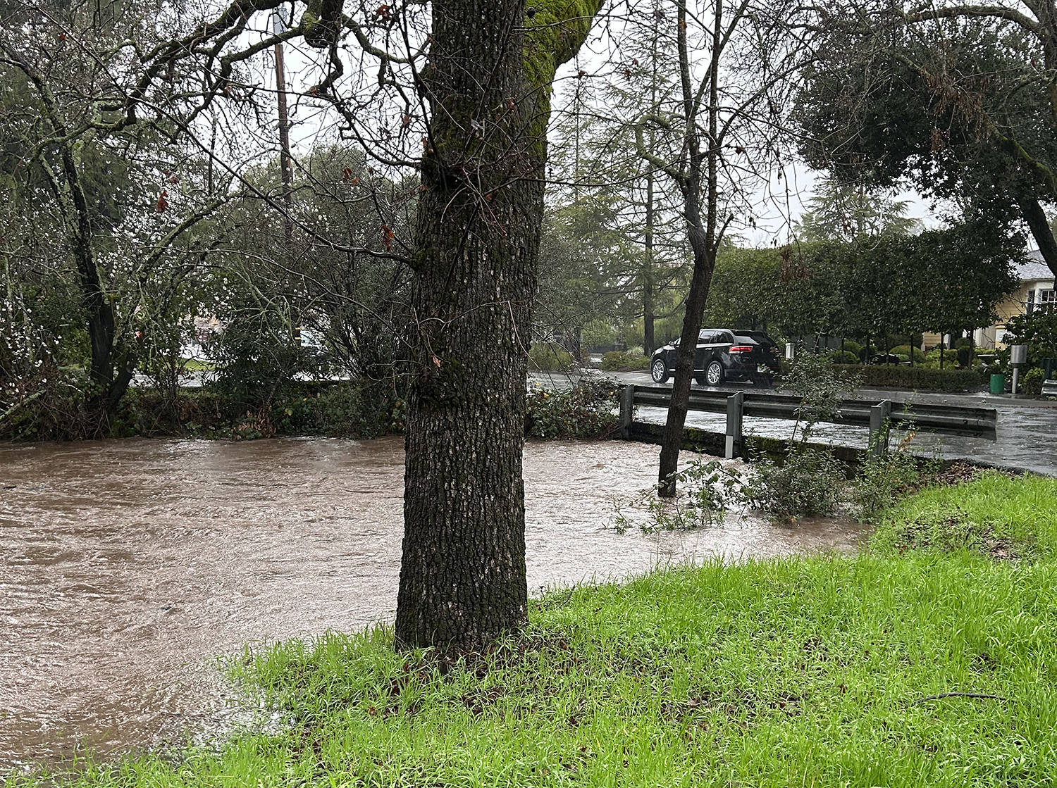
Justification and Eligibility Sonoma Creek is a major waterway of Sonoma Valley, which forms the City’s western boundary and provides a vital wildlife link for the region. The creek system has residential and commercial uses which border it and has potential for public access opportunities. The creek is entirely daylit with riparian vegetation throughout its course. The creek provides an ideal ecosystem for plants and animals within the Valley and can be further protected and enhanced. The Sonoma Creek watershed spans into many other tributaries and supports freshwater wetlands and saltwater marshes in the region. Improvements to the Sonoma Creek PCA could create new and enhanced trails with urban greenways that provide additional recreational access to potential trails and viable alternative transportation routes. Designating this PCA aligns with goals CD-5.3, ER-2.3, ER-2.4, and ER-2.6 (Attachment F), and the open space and recreation sections of the City of Sonoma General Plan Community Development and Environmental Resources Element.
Proposed PCA Name: Regional Trail PCA
Location: From Sonoma Highway to Lovall Valley Road
Type(s): Urban Greening, Recreation, and Climate Adaptation
Justification and Eligibility
The Regional Trail serves as a multimodal trail for local community members and passing regional users. The trail provides safety for pedestrians and bikers as they pass through open spaces and public lands. The trail features multiple parks and access to residences that may utilize the trail regularly. The trail is also tied to historic parks, including Sonoma State Historic Park and Depot Park. The open spaces provide opportunities for gathering and recreation. This PCA would provide opportunities for the City to provide additional recreational access and further connectivity with other trails and the community. This would improve the safety of the trail and make the trail more appealing for users. The trail also holds potential for new urban greening due to multiple public spaces being along the trail. Designating this PCA could improve the quality of the experience when utilizing the trail and improve the climate of the City. The designation aligns with goals CD-5.3, ER-2.3, ER2.4, and ER-2.6 (Attachment F), and the open space and recreation section of the City of Sonoma General Plan Community Development and Environmental Resources Element.
Proposed PCA Name: Nathanson Creek PCA
Location: From Plum Tree Court to Napa Road
Type(s): Urban Greening and Climate Adaptation
Justification and Eligibility
Nathanson Creek is a minor waterway within the City of Sonoma, which meanders through residential properties and some public spaces. The creek system has primarily residential uses bordering it, which have been highly developed. The creek is primarily daylit with riparian vegetation along most of the creek. The creek feeds into a wetland and some small ponds, which are highly vegetated. Improvements have been made to City roads to improve the quality of the creek and further protections may be made to protect its health. This PCA would provide opportunities for the City to provide urban greening areas that serve the health of the creek and the climate within the City. Improvements to the Nathanson Creek PCA could improve the creek’s health and ensure viability of vegetation. This would help to reduce the heat index within the City and improve the health of the environment. Designating this PCA aligns with goals CD-5.3, ER-2.3, ER-2.4, and ER-2.6 (Attachment F), and the open space section of the City of Sonoma General Plan Community Development and Environmental Resources Element.
Proposed PCA Name: Fryer Creek PCA
Location: From Bettencourt Street to Leveroni Road
Type(s): Recreation and Climate Adaptation
Justification and Eligibility
Fryer Creek is a minor waterway within the City of Sonoma, which meanders through residential properties and some public spaces. The creek system has primarily residential uses bordering it, allowing localized access for residents. The creek is primarily daylit with riparian vegetation along most of the creek and features a trail system along a portion of it. Improvements have been made to the bank of the creek to provide recreational opportunities and access to urban green spaces. This PCA would provide opportunities for the City to provide additional recreational opportunities for residents and serve the health of the creek and the climate within the City. Improvements to the Fryer Creek PCA could improve the creek’s health and ensure viability of vegetation. The creek would become more favorable for recreational use and provide a safe route for pedestrians. Designating this PCA aligns with goal CD-5.3, and ER-2.4 (Attachment F) and the open space and recreation section of the City of Sonoma General Plan Community Development and Environmental Resources Element.


The City of Sonoma finally submitted PCA maps, but the public deserves to understand how badly staff missed the mark. The PCA program is meant to unlock funding for projects Sonoma claims to support: trails, habitat corridors, flood protection, climate resilience, groundwater recharge, safe routes to schools, and green infrastructure. Over $85 million has already been awarded to Bay Area cities for these kinds of projects. Napa’s Vine Trail and Sonoma County’s Schellville Trail both received PCA funding. Sonoma could have done the same. It didn’t.
PCA designations are supposed to help cities pre-position for funding. Instead, staff submitted tiny slivers of creek with minimal width, leaving out major trail corridors, uplands, recharge areas, and entire neighborhoods — including the west side of the City facing the greatest climate risks. The community spent 16 months in the General Plan process identifying Greenlinks corridors as clear priorities. Staff ignored those entirely.
The PCA forms staff used specifically encouraged full corridor nominations. They had the authority to include full creek systems, trail networks, and multi-benefit zones. They chose not to. Instead, they cut and pasted eligibility maps while stripping out the actual corridor logic. The result is technically valid, but strategically useless. It directly weakens Sonoma’s position for future grants — severely limiting our options while other cities secure millions.
This was entirely self-inflicted. You can see the difference for yourself:
https://storymaps.arcgis.com/stories/27987105af3d44b79b7368310853816e
Council and the public deserve better.
What happened with PCA previews what’s happening in the General Plan Update. Sonoma is only 2.7 square miles — we don’t have the luxury of doing the bare minimum or defaulting to quick, simple actions. With so little land, every project needs to deliver multiple benefits, maximize every dollar, and fully reflect what this community has asked for: a connected, thriving, resilient, livable Sonoma. We want a lot from limited space — and it’s entirely possible, as neighboring communities show.
The June 4th City Council meeting to review these maps is just a formality. Staff already submitted them to ABAG before Council or the public ever weighed in. Nothing said at this meeting will change what’s already been filed. After-the-fact approval may create the appearance of public input, but in reality, both the public and Council were left out.
Council and the public deserve better.