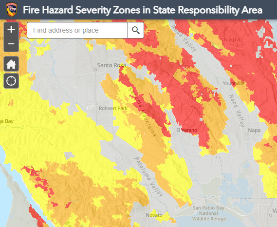
An updated draft Fire Hazard Severity Map is now available for public review and comment. This map is based on CalFire’s updated Fire Hazard Severity Zones, which determine fire hazard classifications for the City of Sonoma, Sonoma Valley, and surrounding areas based on climate data, fire history, and wildfire modeling.
View the Interactive Map & Submit Comments by April 13th on the City’s Local Responsibility Area Fire Hazard Severity Map webpage.
The Fire Hazard Severity Zone (FHSZ) maps are developed using a science-based and field-tested model that assigns a hazard score based on the factors that influence fire likelihood and fire behavior. Many factors are considered such as fire history, existing and potential fuel (natural vegetation), predicted flame length, blowing embers, terrain, and typical fire weather for the area. There are three levels of hazard in the State Responsibility Areas: moderate, high, and very high.
Fire Hazard Severity Zone maps evaluate “hazard,” not “risk”. They are like flood zone maps, where lands are described in terms of the probability level of a particular area being inundated by floodwaters, and not specifically prescriptive of impacts. “Hazard” is based on the physical conditions that create a likelihood and expected fire behavior over a 30 to 50-year period without considering mitigation measures such as home hardening, recent wildfire, or fuel reduction efforts. “Risk” is the potential damage a fire can do to the area under existing conditions, accounting for any modifications such as fuel reduction projects, defensible space, and ignition resistant building construction.


Be First to Comment