Sonoma Creek falls out of Sugarloaf State Park, wanders across the Valley floor and slides down the narrow canyon framing Warm Springs Road, past the first house I owned anywhere. The backyard of that house looked down on the creek, through a picket fence of California Bay Laurel trees that, over the years, one-by-one, succumbed to the hungry water that chewed on the banks during every winter storm.
The force of the flow excited and alarmed me. At various times of high water, I have kayaked the entire creek from Kenwood to tidewater at Millerick Road. It’s not something I would recommend unless you’re an experienced whitewater kayaker, but besides the thrills and the bucolic solitude – there is a remarkably separate wild and wonderful world hidden along that waterway – you can witness the work of a natural force that is constantly resisting constraint. It doesn’t want to be boxed in, and historically, much of the path the creek followed was wider, with large, shallow pools, marshes, small lakes, enough water for rowboats in the summer, enough space to spread out.
It is the fate of most rivers and streams boxed in by agriculture, by infrastructure, by armored banks and leveed walls, that they speed up and dig down. I’ve witnessed this on rivers all over the country and around the world. And I’ve witnessed it in my geologically-short tenure as an inhabitant of the Sonoma Creek watershed.
I moved from that first house to another one downstream, but up the canyon of the tributary Calabazas Creek, and over the course of eight years I watched Calabazas chew up a good hundred feet of stream bank right below my house with periodic ferocity in a bed that frequently went dry in summer.
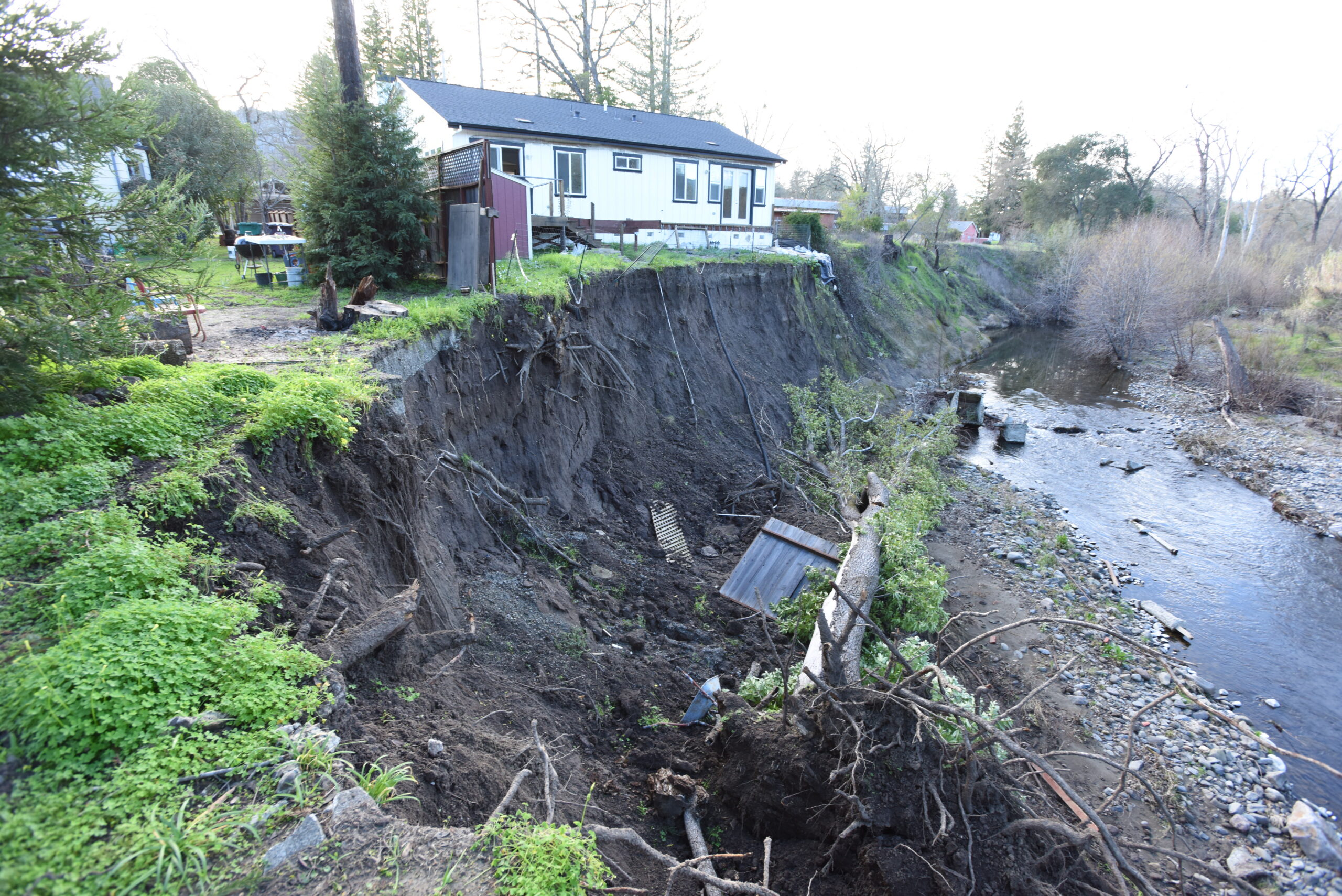
My current house is not on the creek, but about 100 yards away, close enough that on the right flow, I can throw a boat into the water under the old steel Arnold Drive bridge and surf my way down to a little beach a five-minute carry from my backyard fence. And it is maybe 200 yards downstream from that beach, right at the end of Burbank Drive, across the fence from the Sonoma Developmental Center, that an almost new house is on the verge, as this photo reveals, of actually falling into the creek. A particularly ironic fate since the house originally in that space was destroyed during the 2017 Nuns Canyon firestorm.
All of which is meant to illustrate an object lesson – moving water wants to move. It is dynamic, persistent and almost unstoppable. If you’ve ever been to the Grand Canyon, you know this.
Why then would reasonable, sane, educated and presumably intelligent people decide to locate scores of homes along both banks of Sonoma Creek? That’s what the SDC proposal now being redeveloped by Permit Sonoma – the Sonoma County planning department – will do.
Granted, state regulations require a minimum setback of 100 feet from stream banks. But 100 feet in a riparian corridor with the size and the fluvial importance of Sonoma Creek is not a safe or sensible distance. Not for the health of the creek and the creatures dependent on it. And not for the residents of homes that close to it.
Two words we ask Sonoma County planners and Supervisors to learn: fluvial geomorphology. Learn it and study it in the bed of Sonoma Creek. And then decide that placing any houses within the gravitational pull of that waterway is just stupid. Unless you just don’t care about the creek, or about the houses you want to put there.
Photo by David Bolling


I’m glad you wrote this article. I live nearby and have been watching the streambank erosion for years. I’d like to bring the issue of storm drains into the erosion mix.
We share a brick wall in the backyard with the SDC and a few feet beyond it is a large storm drain that runs from somewhere near Arnold Dr. down along the brick walls and fences of Martin St. residences. It empties along the creek bank next to the now abandoned house in your picture, and just beyond the house. If you look down in the creek to the right of the house, you will see rectangular structures that are made out of concrete.
A neighbor has called this an abandoned septic tank that once served the threatened house. However, this collapsed structure is just below where the outfall of the storm drain is. I think is critical to determine if this concrete structure is a remnant of a massive outfall structure of the storm drain. If it is, what has happened is that the stream undermined the drainage structure on the streambank and it eventually broke under its own weight. Then, the water exiting the broken outfall would have significantly washed away the backyard of the threatened house, in addition to the stream. The next house threatened is where you took the photo. You can see the fallen tree that recently fell into the creek.
Also, just upstream from the house is a section of bank that has eroded even further into SDC; the erosion is getting closer to the loop section of Redwood Road. In the center of the most egregious erosion is a plastic storm drain pipe. Erosion has undermined the pipe which eventually breaks. The water from the outfall then erodes the surrounding bank quicker than the stream. After a rain you can see water exiting. What you can’t see is that there are many other storm drain pipes in the trees upstream that have also contributed to the loss of the streambanks.
No doubt heavy rains have cause erosion. However, I suspect that the State is partially responsible for the streambank erosion in the area when they abandoned the maintenance of the storm drains, which likely occurred years or decades ago. It is critically important that any future development in SDC correct the problems with existing storm drains and builds adequate storm drain infrastructure that prevents the severe loss of streambanks that we have witnessed in just a few years.
This is such an important reminder of the power of nature and why we must respect our waterways. Sonoma Creek isn’t just a scenic feature—it’s a dynamic ecosystem that shapes the land and supports countless species. Advocating for responsible setbacks and thoughtful planning is crucial to protect both the creek and the people who live nearby. Thank you for highlighting the importance of understanding fluvial geomorphology before making development decisions.