Evacuation Report Warns of Major Risk Ignored by County
By David Bolling
An authoritative study released Monday by a Sonoma Valley citizen’s group claims that wildfire evacuation data incorporated in the Environmental Impact Report and Specific Plan for the Sonoma Developmental Center (SDC) are wildly unrealistic and dramatically understate the impact of 1,000 new homes proposed there on evacuation times in the event of a wildfire.
The Sonoma Area Fire Evacuation study – captioned the SAFE Report – was conducted by KLD Associates, a San Antonio, Texas company renowned worldwide as experts in evacuation and emergency planning. KLD has conducted wildfire evacuation time studies for Santa Cruz County, Santa Barbara County, and for the Oakmont subdivision at the top of Sonoma Valley, among many others.
Valley residents fleeing a wildfire with even an hour’s notice could expect to spend between four and eight hours – or even more – on traffic-clogged roads, traveling at walking speeds.
The SAFE Report was commissioned and paid for by the Valley of the Moon Alliance (VOTMA), a nonprofit citizens group based in Glen Ellen. In a February 10 press release, VOTMA explains that the SAFE Report was commissioned in part because of a prevailing lack of reliable public information regarding explicit plans for the potential evacuation of the Sonoma Valley in times of encroaching wildfire.
Much of the developed infrastructure of the Valley lies within the so-called wildland-urban interface, those areas where development – primarily housing – merges with forests, scrubland and grasses. The vast majority of all structures destroyed by California wildfires between 1985 and 2013 – more than 80 percent – were in wildland–urban interface zones, as were all the recent wildfires in Sonoma Valley.
The 2017 Nuns Fire, which destroyed parts of Glen Ellen, burned along the periphery of SDC, destroying most of the historic SDC Farm buildings. The fire also traveled down the bed of Sonoma Creek igniting fires in the Eldridge subdivision along the intersection of Martin Street and Burbank Drive. Only the fortuitous and unplanned arrival of a fire truck saved the entire neighborhood from being enflamed.
Compounding the Valley fire risk is the geography of the long, narrow area with only two, parallel north-south arteries – Highway 12 and Arnold Drive, and few east-west lateral routes over the surrounding mountains. With 50,000 people and 44,000 vehicles in that confined space, a wildfire evacuation can quickly clog escape routes.
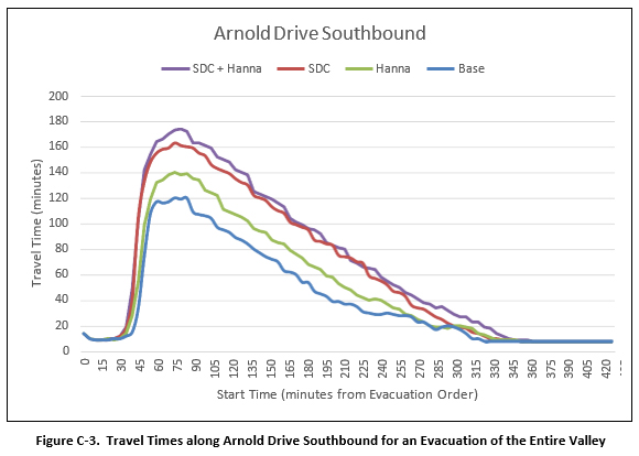
The SAFE Report concludes that during a wildfire evacuation with the existing population distribution, the average vehicle will spend four hours in evacuation traffic, moving at speeds of mostly two-to-three miles per hour. Under conditions of advancing flames and blinding smoke, the Report states, some vehicles could spend eight hours in evacuation traffic. With SDC built out, the evacuation picture changes significantly. And with the proposed Hanna Center development on Agua Caliente Road, the picture grows even more dire.
“Imagine spending four or more hours mired in traffic in the midst of choking smoke and advancing flames. Remember how people burned in their cars during fires in Oakland, Paradise, and Lahaina. This could be any roadway in Sonoma Valley north of the city of Sonoma,” says Kevin Padian, Distinguished Professor Emeritus at UC Berkeley, and a former Fire Board member and Valley resident. “Highway 12 corridor could become a death trap in the next major wildfire.”
Several escape models are included in the SAFE Report, for traffic heading north on both Highway 12 and Arnold Drive, and heading south, with and without the addition of vehicles from a built-out SDC development as currently proposed.
For the projected Arnold Drive southbound model, at 120 minutes after the evacuation notice, it is projected to take motorists 171 minutes to evacuate to Sonoma and beyond under current conditions, versus 285 minutes if the SDC plan were built out. Under present conditions that amounts to nearly three hours. If the current SDC plan were built out, travel time is projected to increase by two-thirds, totaling just under five hours.
These Evacuation Time Estimates (ETE) measure the time it takes evacuees to leave the area at risk, based on established evacuation zones. They do not reflect the time it takes to get to a safe shelter or other location outside the risk area.
A key finding of the SAFE Report is that the available roadway supply – meaning evacuation routes and the roadway network – is not sufficient to allow the entire evacuating population, in the projected number of evacuating vehicles within the valley, to exit without significant delays.
The VOTMA press release charges that, “Sonoma County officials have paid absolutely no attention to these dire calculations.”
The Environmental Impact Report for SDC prepared by Permit Sonoma – the County’s planning agency, projected that the planned 1,000-home SDC development would add only about 90 seconds to Valley evacuation times. But that EIR, along with the County’s entire Specific Plan for SDC, was thrown out by Superior Court Judge Bradford DeMeo, who described the County’s claims as “toothless, vague, and limited to hopeful intentions.”
The SAFE Report, by contrast, is based on actual measurements of road segments, including lane widths, shoulder widths (when present), surface conditions, truck traffic, and traffic signals; survey responses on anticipated evacuation behavior by almost 600 households up and down the Valley; data on actual and estimated use of roads by schoolchildren and parents, commuters, winery employees, and tourists collected by VOTMA, as well as publicly available information. These were integrated into a series of proprietary KLD models explained in the report, and the findings and methods now available to the public.
Bean Anderson, Ph.D., a Sonoma Valley retired engineer, points out, ““The SAFE Report reveals just how unsafe our roads are during emergency evacuations. There hasn’t been significant growth in road capacity for the past 100 years but the population has increased 10-fold.”
A community information meeting to discuss the SAFE Report will be held February 24, at 6:30 p.m. at Altimira Middle School, 17805 Arnold Drive, Sonoma. The complete SAFE Report is now available to the public at https://votma. org/evac-study.


Thank you for an excellent summary and evaluation about the evacuation routes. For those of us who fled Glen Ellen in October 2017 for Sonoma,it was a harrowing trip. We left early as the smoke was getting thick. There only appeared to be one route open at the time and it was south. For those who left later, there was burning along Arnold, with telephone poles ablaze and also brush near Sonoma Creek. Add hundreds of people at SDC site trying to get on the road, and you would get virtual gridlock. The initial evaluation of 90 or so seconds is just a fantasy. Just ask the people who experienced past fire emergencies and they will tell you!
Go figure. This is not something that I imagined would be different. It is getting through to these people that is an art.
SDC should not be able to built more than 50 homes. The impact for fire evacuation would be catastrophic.
Definitely: scale back the SDC project! Not a good project for our community, especially in light of the 2017 wildfire debacle. The message is clear–Sonoma Valley and ancillary areas, such as Bennett Valley, will be mightily impacted when fire erupts again, as it will.
Since it is obvious our roads are already inadequate for successful evacuation of the area, no new housing should be allowed.