This article was originally published by Active Norcal.
The El Niño that scientists have been warning about for months is now official, and the implications for Northern California are enormous.
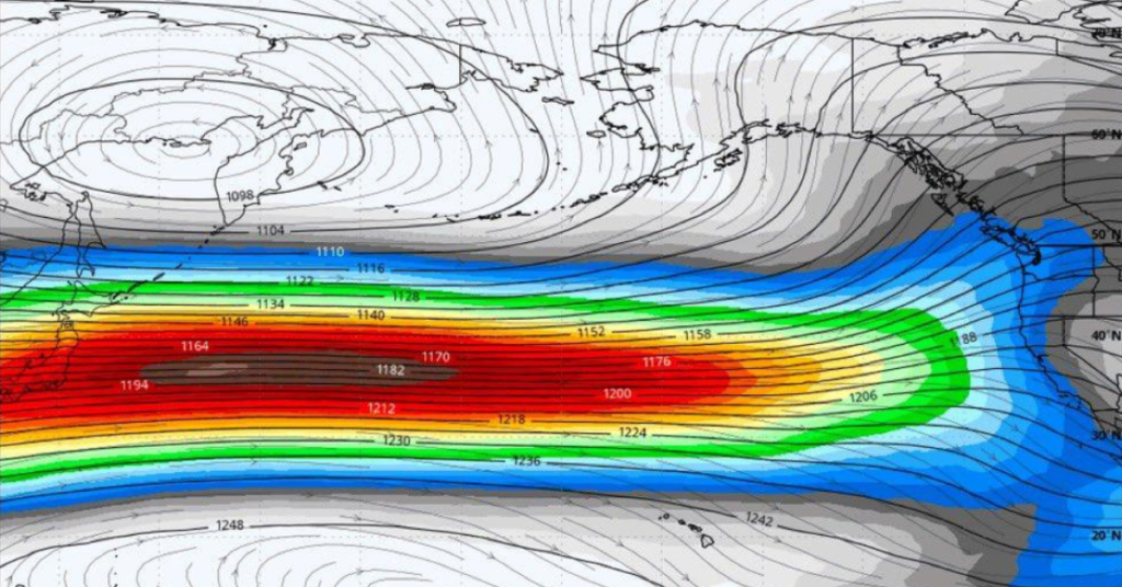
NOAA declared El Niño on Thursday after ocean water temperatures in the tropical Pacific exceeded 0.5 degrees Celsius above average for several consecutive months. The agency issued an El Niño Advisory and forecast that the event will likely strengthen to moderate or strong levels by fall, with a 63% chance of sea surface temperatures exceeding 2.0 degrees Celsius above average, the threshold NOAA uses to classify a very strong El Niño.
If it reaches that level, the 2026-27 El Niño could rank among the strongest on record, alongside the 1997-98 and 2015-16 events that brought historic rainfall, flooding and mudslides to California.
For NorCal, the declaration has two immediate implications. First, the combination of El Niño and an existing marine heat wave creates a double threat to the juvenile salmon that are heading out to sea for the first time since the fishery reopened. Warmer ocean water disrupts the food web that young salmon depend on, and the last major marine heat wave in 2014-15 was blamed for mass die-offs of marine life along the California coast.
Second, a strong El Niño typically shifts the winter storm track southward over California, which can bring above-average rainfall. Strong El Niño years in NorCal have historically averaged about 40 rainy days per winter compared to 26 in non-El Niño years. That could help reservoirs but also increase flood risk.
NOAA says there is a 98.5% chance that 2026 will rank among the five warmest years on record. The strongest impacts are expected between November 2026 and January 2027.


Be First to Comment